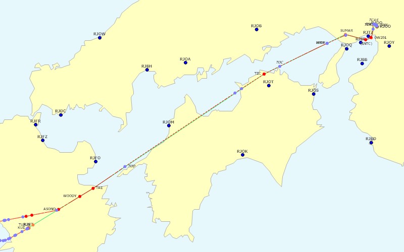
Route:
Weather:
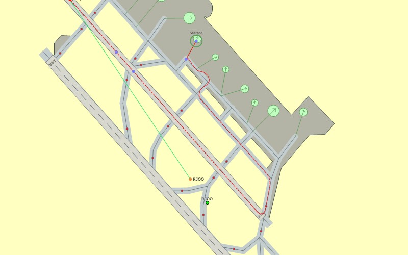
Taxiway Path Out:
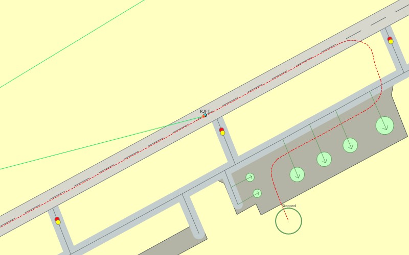
Taxiway Path In:
FS Flight Keeper
Flight RJOO to RJFT
Created On |
Changed On |
|||
2005/04/16 22:13 |
2005/04/16 23:27 |
|||
Aircraft Title |
Aircraft Type |
Tail Number |
Flight Type |
|
PMDG 737-700 |
BOEING AIRCRAFT B737 |
N737PM |
IFR |
|
Airline |
Flight Number |
Flight Level |
Passenger |
Cargo |
Japan Airlines |
2854 |
FL280 |
||
Origin Airport |
Gate |
Runway |
SID |
Transition |
RJOO - Osaka Intl |
Gate 19 |
14L / 32R |
SUMAR1 |
14000 |
Destination Airport |
Gate |
Runway |
STAR |
Transition |
RJFT - Kumamoto |
07 / 25 |
14000 |
||
Alternate Airport |
Pilot |
Logbook |
||
RJFF - Fukuoka |
Sota Suzawa (Japan Airlines) |
My log |
||
| ZFW: |
106,000 lbs |
||||||
| Time OUT: |
2005/04/16 22:12 |
TAW: |
119,492 lbs |
Fuel: |
13,492 lbs |
||
| Time OFF: |
2005/04/16 22:23 |
TOW: |
118,951 lbs |
Fuel: |
12,951 lbs |
TO IAS: |
137kts |
| Time ON: |
2005/04/16 22:22 |
LAW: |
113,047 lbs |
Fuel: |
7,047 lbs |
LA IAS: |
121kts |
| Time IN: |
2005/04/16 22:27 |
RAW: |
112,830 lbs |
Fuel: |
6,830 lbs |
||
| Start mode: |
Taxiing origin |
End mode: |
Taxiing destination |
||||
| Block Time: |
01:15 |
Block Fuel: |
6,662 lbs |
Distance: |
315nm / 265nm |
||
| Flight Time: |
00:59 |
Flight Fuel: |
5,904 lbs |
||||
| ZFW: |
106,000 lbs |
||||||
| Gate: |
Gate 19 |
Position: |
N34* 47.5306' / E135* 26.3036' |
||||
| Altitude: |
-154ft |
Season: |
Spring |
Daytime: |
Night |
Transponder: |
4133 |
| Time OUT: |
2005/04/16 22:12 |
TAW: |
119,492 lbs |
Fuel: |
13,492 lbs |
Max GS: |
25kts |
| Time OFF: |
2005/04/16 22:23 |
TOW: |
118,951 lbs |
Fuel: |
12,951 lbs |
TO IAS: |
137kts |
| Engine settings: |
/E1N1 94 /E1N2 93 /E2N1 94 /E2N2 93 |
||||||
| Flaps: |
10 |
VS: |
20.76 |
Pitch: |
-8.73 |
Bank: |
0.18 |
| Runway: |
14L / 32R |
Surface: |
Asphalt (Normal) |
Heading: |
323 |
||
| OAT: |
14��C |
Dew Point: |
2��C |
Wind: |
61/2 |
Visibility: |
51nm (Normal) |
| Pressure: |
30.12 |
Altimeter: |
30.12 |
Daytime: |
Night |
||
| Spoilers: |
Down |
Autobrakes: |
Off |
Anti-Ice: |
Off |
Flight Director: |
Off |
| Lights: |
NAV|BCN|LAND|STROBE|INST|WING|LOGO |
Autothrottle: |
Off |
||||
| Gear Up: |
729ft / 159kts (22:23) |
Flaps Up: |
5385ft / 204kts (22:24) |
||||
| Autopilot: |
---- |
||||||
| ZFW: |
106,000 lbs |
||||||
| Gate: |
Position: |
N32* 50.1006' / E130* 51.4511' |
|||||
| Altitude: |
640ft |
Season: |
Spring |
Daytime: |
Night |
Transponder: |
4133 |
| Time IN: |
2005/04/16 22:27 |
RAW: |
112,830 lbs |
Fuel: |
6,830 lbs |
Max GS: |
---- |
| Time ON: |
2005/04/16 22:22 |
LAW: |
113,047 lbs |
Fuel: |
7,047 lbs |
LA IAS: |
121kts |
| Engine settings: |
/E1N1 31 /E1N2 64 /E2N1 31 /E2N2 64 |
||||||
| Flaps: |
40 |
VS: |
-317.59 |
Pitch: |
-5.78 |
Bank: |
-0.31 |
| Runway: |
07 / 25 |
Surface: |
Concrete (Normal) |
Heading: |
71 (-0.64) |
||
| OAT: |
10��C |
Dew Point: |
4��C |
Wind: |
190/2 |
Visibility: |
36nm (Normal) |
| Pressure: |
30.18 |
Altimeter: |
30.18 |
Daytime: |
Night |
||
| Spoilers: |
100% |
Autobrakes: |
Off |
Anti-Ice: |
Off |
Flight Director: |
Off |
| Lights: |
NAV|BCN|LAND|STROBE|INST|WING|LOGO |
Autothrottle: |
Off |
||||
| Gear Down: |
3448ft / 208kts (22:18) |
Flaps Down: |
5177ft / 240kts (22:17) |
||||
| Autopilot: |
---- |
||||||
| Avg. FPS: |
19.54 |
Avg. FPS Origin/Flight/Destination: |
17.34 / 20.17 / 15.27 |
||||
| Avg. TAS: |
351kts |
Max. TAS: |
464kts |
||||
| Max. IAS Depar.: |
251kts |
Max. IAS Appr.: |
254kts |
||||
| Avg. Climb: |
2515.37 |
Max. Climb: |
5413.65 |
||||
| Avg. Descent: |
-1642.71 |
Max. Descent: |
-3325.86 |
||||
| Avg. G-Force: |
0.98 |
Min. G-Force: |
0.86 |
Max. G-Force: |
1.19 |
||
| Max. Pitch: |
-21.42 |
Max. Bank: |
-28.42 |
||||
| Max. EGT: |
695��C |
Engine setting: |
97.94 |
Vibration: |
2.16 |
||
| Day Flight Time: |
00:00 |
Night Flight Time: |
00:59 |
||||
| Origin: |
RJOO 161230Z VRB03KT CAVOK 15/02 Q1020 RMK A3014 |
| |
***** METAR Report for RJOO ***** Zulu Time: 12:30 (day 16 of month) Wind: Variable at 03 Ceiling: Ceiling and visibility are OK Temperature: 15��C Dewpoint: 2��C Humidity: 42% Barometer: 30.12hg Remarks: A3014 |
| Destination: |
RJFT 161200Z 19003KT CAVOK 11/03 Q1022 |
| |
***** METAR Report for RJFT ***** Zulu Time: 12:00 (day 16 of month) Wind: 190/03 Ceiling: Ceiling and visibility are OK Temperature: 11��C Dewpoint: 3��C Humidity: 58% Barometer: 30.18hg |
| Alternate: |
RJFF 161400Z 12003KT CAVOK 11/05 Q1022 |
| |
***** METAR Report for RJFF ***** Zulu Time: 14:00 (day 16 of month) Wind: 120/03 Ceiling: Ceiling and visibility are OK Temperature: 11��C Dewpoint: 5��C Humidity: 67% Barometer: 30.18hg |
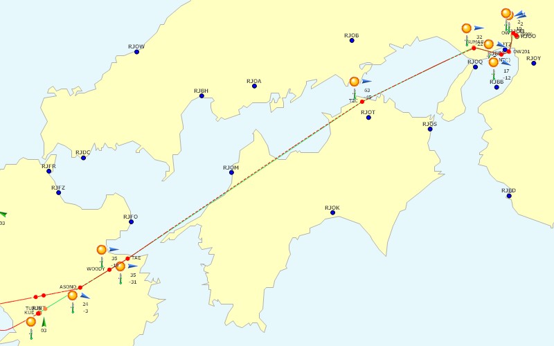
| Name | Type | Time | Fuel (lbs) | IAS (kts) | Altitude (ft) | Heading | Wind | OAT (C) | |
| 1 | RJOO | Airport | 22:23 | 12,947 | 139 | 48 | 323 | 61/2 | 14 |
| 2 | (500) | Intersection | 22:23 | 12,919 | 151 | 124 | 323 | 65/2 | 14 |
| 3 | OW | NDB | 22:23 | 12,734 | 171 | 1829 | 287 | 70/2 | 10 |
| 4 | OW201 | Intersection | 22:25 | 12,105 | 251 | 9370 | 235 | 299/10 | -2 |
| 5 | (INTC) | Intersection | 22:26 | 11,925 | 285 | 11730 | 277 | 302/17 | -12 |
| 6 | SUMAR | Intersection | 22:28 | 11,545 | 312 | 16011 | 266 | 277/32 | -22 |
| 7 | TZC | VOR | 21:39 | 10,283 | 313 | 28000 | 252 | 259/63 | -45 |
| 8 | TAE | VOR | 21:59 | 8,465 | 289 | 19857 | 249 | 274/35 | -31 |
| 9 | WOODY | Intersection | 22:01 | 8,416 | 298 | 14854 | 252 | 274/35 | -19 |
| 10 | ASONO | Intersection | 22:04 | 8,305 | 240 | 9999 | 253 | 297/24 | -3 |
| 11 | TUJUN | Intersection | 22:08 | 8,017 | 239 | 10000 | 270 | 297/24 | -3 |
| 12 | KUE | VOR | 22:09 | 7,955 | 240 | 10000 | 270 | 297/24 | -3 |
| 13 | RJFT | Airport | 22:22 | 7,046 | 117 | 641 | 71 | 190/2 | 10 |
| Type | Event | Time | Fuel (lbs) | IAS (kts) | Altitude (ft) | |
| 1 | Altimeter | 30.12 | 22:13 | 13,492 | 0 | 47 |
| 2 | Lights | BCN|INST|LOGO | 22:16 | 13,492 | 0 | 47 |
| 3 | Parking brake | On | 22:17 | 13,492 | 0 | 47 |
| 4 | Parking brake | Off | 22:17 | 13,492 | 0 | 47 |
| 5 | Pushback | Straight | 22:17 | 13,492 | 0 | 47 |
| 6 | Engine | On | 22:17 | 13,492 | 2 | 47 |
| 7 | Engine Starter | /E1 Start /E2 Start | 22:17 | 13,492 | 2 | 47 |
| 8 | Engine Starter | /E1 Off /E2 Off | 22:18 | 13,485 | 3 | 47 |
| 9 | Engine Starter | /E1 Gen /E2 Gen | 22:18 | 13,477 | 3 | 47 |
| 10 | Transponder | 2200 | 22:18 | 13,454 | 3 | 47 |
| 11 | Pushback | Stopped (pushed for 80s / 377ft) | 22:18 | 13,452 | 2 | 47 |
| 12 | Parking brake | On | 22:18 | 13,450 | 0 | 47 |
| 13 | Transponder | 4133 | 22:19 | 13,431 | 0 | 47 |
| 14 | Lights | BCN|TAXI|INST|LOGO | 22:19 | 13,421 | 0 | 47 |
| 15 | Parking brake | Off | 22:20 | 13,382 | 0 | 47 |
| 16 | Flaps | 10 | 22:20 | 13,373 | 1 | 47 |
| 17 | Lights | BCN|LAND|INST|LOGO | 22:22 | 13,141 | 6 | 47 |
| 18 | Lights | NAV|BCN|LAND|STROBE|INST|WING|LOGO | 22:22 | 13,132 | 8 | 47 |
| 19 | Rotate | VR = 130kts | 22:23 | 12,963 | 130 | 47 |
| 20 | OFF | OFF 22:23 /FOB 12,951 lbs /TOW 118,951 lbs | 22:23 | 12,951 | 137 | 48 |
| 21 | Navigation | (500) | 22:23 | 12,919 | 152 | 126 |
| 22 | Weather | RJOO 161230Z VRB03KT CAVOK 15/02 Q1020 RMK A3014 | 22:23 | 12,904 | 154 | 206 |
| 23 | Altitude | Climbing at 0ft | 22:23 | 12,898 | 155 | 259 |
| 24 | Gear | going Up | 22:23 | 12,898 | 155 | 264 |
| 25 | TCAS | Traffic - ANA645 /DST 10.27nm /HDG 315 /ALT 2708ft /GS 129kts /VS -723ft/min | 22:23 | 12,863 | 157 | 570 |
| 26 | TCAS | Traffic - JA8195 /DST 0.88nm /HDG 165 /ALT 47ft /GS 0kts /VS 0ft/min | 22:23 | 12,863 | 157 | 573 |
| 27 | Gear up | Up and locked after Takeoff | 22:23 | 12,847 | 159 | 729 |
| 28 | Localizer | Active | 22:23 | 12,760 | 174 | 1510 |
| 29 | Localizer | Captured | 22:23 | 12,746 | 173 | 1678 |
| 30 | Navigation | OW | 22:23 | 12,734 | 171 | 1833 |
| 31 | Weather | RJOO 161230Z VRB03KT CAVOK 15/02 Q1020 RMK A3014 | 22:23 | 12,732 | 170 | 1884 |
| 32 | TCAS | Traffic - ANA645 /DST 9.97nm /HDG 314 /ALT 2096ft /GS 102kts /VS -798ft/min | 22:23 | 12,689 | 168 | 2362 |
| 33 | Flaps | 5 | 22:24 | 12,628 | 160 | 3041 |
| 34 | Flaps | 2 | 22:24 | 12,546 | 173 | 3980 |
| 35 | Lights | NAV|BCN|STROBE|INST|WING|LOGO | 22:24 | 12,471 | 183 | 4782 |
| 36 | Flaps | 1 | 22:24 | 12,459 | 187 | 4884 |
| 37 | Flaps up | after Takeoff | 22:24 | 12,405 | 204 | 5385 |
| 38 | Navigation | OW201 | 22:25 | 12,105 | 251 | 9374 |
| 39 | Weather | RJOO 161230Z VRB03KT CAVOK 15/02 Q1020 RMK A3014 | 22:25 | 12,103 | 251 | 9414 |
| 40 | Navigation | (INTC) | 22:26 | 11,925 | 285 | 11732 |
| 41 | Weather | RJOO 161230Z VRB03KT CAVOK 15/02 Q1020 RMK A3014 | 22:26 | 11,923 | 286 | 11743 |
| 42 | Pressure | 30.13 | 22:27 | 11,683 | 316 | 15159 |
| 43 | COM1 | 118.900 | 22:28 | 11,594 | 312 | 15996 |
| 44 | Altitude | Level off at 16000ft | 22:28 | 11,548 | 312 | 16007 |
| 45 | Navigation | SUMAR | 22:28 | 11,545 | 312 | 16011 |
| 46 | Weather | RJBB 161230Z 18005KT CAVOK 14/07 Q1021 BECMG 13004KT | 22:28 | 11,544 | 312 | 16012 |
| 47 | Altitude | Climbing at 16000ft | 22:31 | 11,315 | 317 | 16177 |
| 48 | Warning | ZULU/GMT Time has been changed by more than 5 minutes (correcting -60 minutes) | 21:31 | 11,315 | 317 | 16177 |
| 49 | Pause | On | 21:31 | 11,315 | 317 | 16177 |
| 50 | Warning | ZULU/GMT Time has been corrected. Automatic correction has been turned off. | 21:31 | 11,315 | 317 | 16177 |
| 51 | Warning | Scenery changed or reloaded | 21:31 | 11,315 | 317 | 16177 |
| 52 | Pause | Off | 21:31 | 11,315 | 317 | 16177 |
| 53 | Altitude | Level off at 28000ft | 21:38 | 10,457 | 313 | 28000 |
| 54 | Navigation | TZC | 21:39 | 10,283 | 313 | 28000 |
| 55 | Weather | RJOT NIL | 21:39 | 10,280 | 313 | 28000 |
| 56 | Altimeter | 29.92 | 21:42 | 10,043 | 312 | 27835 |
| 57 | Altitude | Climbing at 27800ft | 21:42 | 10,017 | 312 | 27953 |
| 58 | Altitude | Level off at 28000ft | 21:43 | 9,939 | 311 | 27993 |
| 59 | Turbulence | Light | 21:43 | 9,879 | 311 | 27995 |
| 60 | COM2 | 118.300 | 21:44 | 9,837 | 311 | 28003 |
| 61 | Turbulence | None | 21:45 | 9,729 | 311 | 28000 |
| 62 | COM2 | 121.200 | 21:45 | 9,704 | 311 | 27997 |
| 63 | COM2 | 119.900 | 21:45 | 9,676 | 304 | 27997 |
| 64 | Altitude | Descending at 28000ft | 21:55 | 8,669 | 314 | 27836 |
| 65 | Navigation | TAE | 21:59 | 8,465 | 289 | 19853 |
| 66 | Weather | RJFO 161200Z VRB03KT CAVOK 12/03 Q1021 | 21:59 | 8,465 | 290 | 19816 |
| 67 | Pressure | 30.16 | 22:00 | 8,428 | 299 | 15965 |
| 68 | Navigation | WOODY | 22:01 | 8,416 | 298 | 14854 |
| 69 | Weather | RJFO 161200Z VRB03KT CAVOK 12/03 Q1021 | 22:01 | 8,416 | 298 | 14829 |
| 70 | Turbulence | Light | 22:01 | 8,413 | 290 | 14495 |
| 71 | Turbulence | None | 22:01 | 8,389 | 294 | 12287 |
| 72 | Pressure | 30.17 | 22:02 | 8,378 | 291 | 11355 |
| 73 | Altimeter | 30.17 | 22:03 | 8,349 | 240 | 10663 |
| 74 | Navigation | ASONO | 22:04 | 8,305 | 240 | 9999 |
| 75 | Weather | RJFT 161200Z 19003KT CAVOK 11/03 Q1022 | 22:04 | 8,305 | 240 | 9999 |
| 76 | Altitude | Level off at 10000ft | 22:04 | 8,286 | 239 | 10001 |
| 77 | NAV1 | 109.300 - IKU (RJFT - CAT III ILS 07) | 22:04 | 8,284 | 239 | 10003 |
| 78 | Pressure | 30.18 | 22:05 | 8,224 | 240 | 9997 |
| 79 | Navigation | TUJUN | 22:08 | 8,017 | 239 | 10000 |
| 80 | Weather | RJFT 161200Z 19003KT CAVOK 11/03 Q1022 | 22:08 | 8,016 | 239 | 10000 |
| 81 | Navigation | KUE | 22:09 | 7,955 | 240 | 10000 |
| 82 | Weather | RJFT 161200Z 19003KT CAVOK 11/03 Q1022 | 22:09 | 7,954 | 240 | 10000 |
| 83 | Altitude | Descending at 10000ft | 22:09 | 7,924 | 243 | 9844 |
| 84 | Altimeter | 30.18 | 22:09 | 7,923 | 244 | 9797 |
| 85 | Glideslope | Active | 22:11 | 7,860 | 240 | 5998 |
| 86 | Altitude | Level off at 6000ft | 22:12 | 7,822 | 240 | 5994 |
| 87 | Glideslope | Captured | 22:12 | 7,814 | 243 | 5839 |
| 88 | Altitude | Descending at 6000ft | 22:12 | 7,814 | 243 | 5832 |
| 89 | Altitude | Level off at 3400ft | 22:14 | 7,725 | 239 | 3402 |
| 90 | Altitude | Climbing at 3400ft | 22:16 | 7,593 | 235 | 3566 |
| 91 | NAV2 | 109.300 - IKU (RJFT - CAT III ILS 07) | 22:16 | 7,530 | 240 | 4335 |
| 92 | Localizer | Active | 22:16 | 7,513 | 239 | 4560 |
| 93 | Flaps down | for Landing | 22:17 | 7,460 | 240 | 5177 |
| 94 | Flaps | 2 | 22:17 | 7,441 | 241 | 5368 |
| 95 | Altitude | Descending at 5300ft | 22:17 | 7,421 | 243 | 5121 |
| 96 | Localizer | Captured | 22:17 | 7,413 | 241 | 4763 |
| 97 | Flaps | 5 | 22:18 | 7,392 | 227 | 3702 |
| 98 | Gear | going Down | 22:18 | 7,391 | 226 | 3672 |
| 99 | Gear down | Down and locked for Landing | 22:18 | 7,386 | 208 | 3448 |
| 100 | Flaps | 10 | 22:18 | 7,385 | 205 | 3417 |
| 101 | Lights | NAV|BCN|LAND|STROBE|INST|WING|LOGO | 22:19 | 7,378 | 189 | 3225 |
| 102 | Flaps | 15 | 22:19 | 7,372 | 186 | 3141 |
| 103 | Spoilers | 34% | 22:19 | 7,369 | 184 | 3107 |
| 104 | Flaps | 25 | 22:19 | 7,347 | 169 | 2789 |
| 105 | Flaps | 30 | 22:19 | 7,291 | 156 | 2291 |
| 106 | Flaps | 40 | 22:20 | 7,273 | 146 | 2092 |
| 107 | Markers | Outer | 22:20 | 7,262 | 136 | 1964 |
| 108 | Markers | Middle | 22:21 | 7,081 | 129 | 840 |
| 109 | Markers | Inner | 22:21 | 7,063 | 129 | 750 |
| 110 | ON | ON 22:22 /FOB 7,047 lbs /LAW 113,047 lbs | 22:22 | 7,047 | 121 | 641 |
| 111 | Spoilers | fully Deployed | 22:22 | 7,045 | 107 | 640 |
| 112 | Lights | NAV|BCN|TAXI|STROBE|INST|WING|LOGO | 22:22 | 7,039 | 50 | 640 |
| 113 | Spoilers | Down | 22:22 | 7,035 | 46 | 640 |
| 114 | Flaps | 0 | 22:25 | 6,892 | 22 | 640 |
| 115 | Engine Starter | /E1 Off /E2 Off | 22:26 | 6,830 | 0 | 640 |
| 116 | Lights | TAXI|INST | 22:26 | 6,830 | 0 | 640 |
| 117 | Lights | INST | 22:26 | 6,830 | 0 | 640 |
Sota Suzawa |
Field 2 |
Field 3 |
Field 4 |
Field 5 |
Field 6 |
Field 7 |
Field 8 |
Field 9 |
Field 10 |
Comment |
|
Route: |
|
Weather: |
|
Taxiway Path Out: |
|
Taxiway Path In: |
|