EHSI MAP DISPLAY
EHSI マップ表示
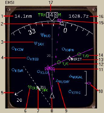
1- Distance Marker: It displays the distance to the active FMC waypoint.
距離マーカー:FMC のアクティブなウェイポイントまでの距離が表示されます
2- Magnetic Heading Pointer: The magnetic heading of the aircraft is shown using this triangle.
磁方位ヘディングポインター:飛行機の磁方位ヘディングがこの三角で示されます
In this case the magnetic heading is 357.
この図の場合は磁方位ヘディングは 357 となります
When the map is displayed, the actual aircraft track is shown in #17.
マップが表示されている時は、17. のように現在の飛行機の進路が表示されます
Because of the wind from the right (#5) the actual aircraft track along the ground is 348.
なぜならば ( 5. ) のように右から風が吹いているためで、実際の飛行機は 348 度の方向に進んでいます
3- VOR Symbol: When the NAVAID button is pressed on the EHSI Control panel, all VORs are displayed within the selected EHSI range.
VOR シンボル:EHSI コントロールパネル上の NAVAID ボタンを押した場合、選択されている EHSI レンジ内の全ての VOR が表示されます
In the 80-mile mode and above, only high altitude VORs are displayed.
80 マイルモード以上では VOR が表示される高度以上で表示されます
4- Airport Symbol: When the ARPT button is pressed on the EHSI Control panel, all airports with runways greater than 4,500 feet are displayed within the selected EHSI range.
空港シンボル:EHSI コントロールパネル上の ARPT ボタンを押した場合、選択されている EHSI レンジ内の 4,500 フィート以上の滑走路を持つ全ての空港が表示されます
5- Wind Vector: It displays the direction and speed of the wind.
風のベクトル:風速と風向が表示されます
The wind arrow is oriented based on map track display.
風の矢印はマップの方位にしたがって表示されます
6- Auto-Tuned VOR Symbol: The VORs that are presently auto-tuned by the FMC are displayed in green.
自動チューニング VOR シンボル:FMC で設定されている、まもなく自動チューニングされる VOR がグリーンで表示されます
The only time the FMC can auto-tune a VOR is when the NAV1 mode button is in AUTO.
FMC の自動チューニング VOR は NAV1 モードが AUTO になっている時のみ働きます
7- Departure/Arrival Runway Symbol: When a departure or arrival runway is selected in the FMC, the runway is depicted as such.
出発/到着滑走路シンボル:出発または到着滑走路が FMC で選択されている時、滑走路自体が描かれます
Two parallel lines represent the runway and are drawn to the exact length of the runway.
2つの平行した線が滑走路を表しており、滑走路の正確な長さが描かれています
027
The dashed extended centerlines are 14.2nm in length from the end of each runway.
点線の中心線の延長はそれぞれの滑走路エンドから 14.2 マイルの長さが描かれます
In the 80-mile range and above, this symbol is replaced by a white circle and line oriented toward the runway heading.
80 マイルレンジ以上ではこのシンボルは滑走路方位を示す白い丸と線に置き換わります
8- Airplane Symbol: The tip of the triangle is the present aircraft position.
飛行機シンボル:三角形は現在の飛行機の位置です
9- Waypoint Symbol: When the WPT button is pressed on the EHSI Control panel, all waypoints in the vicinity of the aircraft are displayed.
ウェイポイントシンボル:EHSI コントロールパネル上の WPT ボタンを押した時、飛行機に近接した全てのウェイポイントが表示されます
The waypoints are only displayed in the 40-mile mode and lower.
ウェイポイントは 40 マイルモード以下で表示されます
10- Vertical Track Indicator (VTI): When making a VNAV descent this display comes up.
垂直方向の進路表示 ( VTI ) :VNAV で降下されている時にこの表示が現れます
It is referred to as a “poor mans glideslope” because it is calibrated to show you if you are within +/- 400 feet of the VNAV vertical track.
poor mans glideslope を参照してください。なぜなら、もし VNAV の垂直進路が +/- 400 フィート以下ならキャリブレートします
This track is based on waypoint altitude constraints.
この進路はウェイポイント上の高度の強制が基本です
If the pointer is in the middle, then the aircraft is on vertical track and will reach each waypoint listed in the LEGS page of the FMC at the programmed altitude.
もしポインターが真中にある場合は、飛行機は垂直トラックに乗っており、FMC の LEGS ページでプログラムされているウェイポイントの高度に到着するでしょう
11- FMC Active Waypoint: This is the active waypoint in the FMC.
FMC アクティブウェイポイント:これは FMC のアクティブウェイポイントです
When LNAV is engaged, the AFDS navigates the aircraft to this waypoint by following the magenta course line.
LNAV が機能している時、AFDS が飛行機をマゼンタ色のコースラインに沿って、このウェイポイントにナビゲートします
The name of the waypoint is also listed (in this case LGA01).
ウェイポイントの名前もリスト表示されます ( この図の場合では LGA01 )
12- Top of Climb Prediction (T/C): The FMC predicts when the aircraft will reach the FMC programmed cruise altitude.
予測上昇頂点 ( T/C ) :FMC は飛行機が FMC のプログラムどおりの巡航した場合の高度を予測します
That point is shown along the FMC track using the T/C symbol.
この点は FMC のトラックに沿って T/C シンボルが使われ表示されます
13- In-Active Waypoint: The inactive down line waypoints in the FMC route are displayed in white.
活動しないウェイポイント:FMC ルートの中の活動しないウェイポイントは白色で表示されます
In this case the MERIT intersection.
この図の場合は MERIT 交差点です
All waypoints are connected using the magenta course line that is the eventual track the aircraft shall follow.
全てのウェイポイントは飛行機が従うであろうマゼンタ色のコースラインにつながって使用されます
14- Top of Descent Prediction (T/D): The FMC predicts when the aircraft must start its descent based on FMC programmed altitude constraints for each waypoint in the LEGS page.
予測降下開始位置 ( T/D ) :FMC は飛行機が FMC の LEGS ページのそれぞれのウェイポイントでの強制高度を基本に降下開始しなければならない地点を予測します
From this point the aircraft can make an idle power descent to reach the first altitude constraint.
このポイントから飛行機はアイドルパワーで降下をはじめ、最初の強制高度に届きます
15- AFDS Heading Bug: The heading dialed into the AFDS HDG window is displayed using this dashed line and bug.
AFDS ヘディングバグ:この AFDS HDG ウィンドウのヘディングダイアルはこの点線とバグで表示されます
If in HDG SEL mode the magnetic heading triangle (#2) lines up with the heading bug when the aircraft is on the selected AFDS heading.
もし HDG SEL モードの場合に AFDS ヘディングが選択されている場合、磁方位ヘディングは三角 ( 2. ) とラインとヘディングバグで表示されます
This heading will be different from the aircraft track (#17) because of wind affecting the aircraft ground track.
このヘディングは飛行機の進路 ( 17. ) とは違っています。というのは飛行機の地上進路とは風の影響があるためです
16- Waypoint Crossing Time: The Zulu time at which the aircraft will cross the active FMC waypoint.
ウェイポイント通過時間:FMC のアクティブウェイポイントを通過する標準時間です
17- Aircraft Track Display: When in the MAP mode, the EHSI displays aircraft track in the center of the display.
飛行機の進路表示:マップモードの場合、EHSI 表示はディスプレイの中心に飛行機の進路を表示します
TRK indicates that the heading listed in the box is the actual aircraft track across the ground.
TRK 表示はボックスの中にヘディングが表示されます。地上に対する現在の飛行機の進路です
Aircraft magnetic heading and wind component determine the ground track.
飛行機の磁方位ヘディングと風の成分は地上の進路を確定します
In this case the aircraft's track along the ground is 348.
このケースでは飛行機の進路は地上の 348 度へ向かっています
You can see from the heading triangle (#2) that the aircraft magnetic heading is 357.
ヘディングの三角 ( 2. ) から飛行機の磁方位ヘディングは 357 度であることが分ります
You can also see that a right crosswind exists based on the wind component display (#5).
風成分表示 ( 5. ) によって右から風があることもまた見ることができます
Thus, if you stay on your current magnetic heading and the winds remain steady, your aircraft will follow the 348 degree ground track as displayed by the grey track line ahead of the aircraft symbol.
このようにして、もし現在の磁方位ヘディングを保持して風も現状のままならば飛行機シンボルの先の灰色のトラックライン 348 度に沿って飛行することになります